If you are in Half Moon Bay in Northern California and looking for a great way to spend your morning for a half day walk or even a full day of explorations, there are several Half moon bay hikes and trails that are not to be missed.
Best part about the Half moon bay hikes and trails are that most of them are stroller, wheelchair and dog friendly. Read on to pick the perfect trail for your fitness and style.
Half Moon Bay Coastal Trail to Miramar Beach
Description of Half Moon Bay Coastal Trail :
Taking you along Pacific ocean in Half Moon Bay, this section of Coastal trail connects two beach parks. The trail is easy to hike. However, you may not find trail marking along the way. Only way to figure out is to just walk till the next sandy beach as long as ocean view is on the west side of the hike. Watch out! You might be blown away by the wildly blooming nasturtium vines and crocus flower along the way.
Round trip length of Half Moon Bay Coastal Trail :
It’s a good 5 mile round trip from Half Moon Bay State beach to Miramar beach and back.
Elevation gain of Half Moon Bay Coastal Trail :
~ 200 feet of elevation gain as you are walking through the bluffs.
Who is this trail for ?
- Kids friendly
- Dogs friendly
- Bike and hiker friendly
- NOT stroller friendly as only part of the trail is paved.
How to get to Half Moon Bay Coastal Trail and where to park ?
Park at either Miramar beach or at Half Moon bay state beach parking lots to hike in either direction.
Blufftop Coastal Park
Description of Blufftop Coastal Park :
Technically this is the same trail as the Half Moon bay coastal trail. I just split it up for those interested in shorter hikes. So, you can either walk from Poplar beach all the way to Miramar Beach or return back from Half Moon bay state beach. You have choices.
Keep in mind these are wide open trails with no shades. On a hot day, plan accordingly if you attempting the longer sections of this trail.
Round trip length of Blufftop Coastal Park :
From Blufftop Coastal Park (Poplar Beach) to Half Moon bay state beach is 2 miles round trip.
Elevation gain of Blufftop Coastal Park :
Barely any. It’s as flat as it can get in bay area.
Who is this trail for ?
- Kids and stroller friendly
- Horses share this trail
- Dogs on leash are allowed
- Bikers and walkers
How to get to Blufftop Coastal Park and where to park ?
You can park either at Blufftop coastal park or at the Half Moon bay state beach.
Half Moon Bay Coastal Trail to Poplar Beach
Description of Half Moon Bay Coastal Trail :
This Southern section of Half Moon bay coastal trail starts at the southmost trail head start and goes up to Poplar beach via the famous Ritz Carlton in Half moon bay. As mentioned earlier, you can walk all the way from here to Miramar for a good 6.5 miles one way if you want to. I have decided to split it up to showcase how this hike can be done in chunks.
Round trip length of Half Moon Bay Coastal Trail :
Approximately 6 miles of round trip.
Elevation gain of Half Moon Bay Coastal Trail :
Flat course.
Who is this trail for ?
- Kids and stroller friendly (there are some unpaved sections along the way. A sturdy stroller should do just fine)
- Horses share this trail
- Dogs on leash are allowed
- Bikers and walkers
How to get to Half Moon Bay Coastal Trail and where to park ?
You can part at Miramontes Point Beach Parking, Half Moon Bay, CA 94019 or at the other end on Poplar beach.
Quarry Park Loop
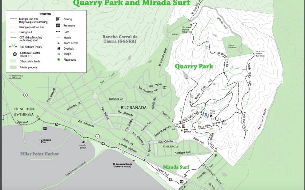
Description of Quarry Park Loop :
Low trafficked hiking trail in the Half Moon Bay hikes and trails system, where you will be walking among aromatic eucalyptus trees as you start the hike. On a foggy day, the view point at the top might hide the ocean view. As the fog lifts up, you can get a great view of the ocean.
The hike is good if you are looking for a moderate workout. There is gradual up hill at the beginning of the hike.
I tried creating a map with google maps for your use, but somehow i couldn’t. So, I posted Official Park map above. There are several trail that fork in and out. If you are going for the ocean view, go for the “Vista Point trail”.
Round trip length of Quarry Park Loop:
It’s approximately a 4 mile round trip.
Elevation gain of Quarry Park Loop :
Nearly 1000ft elevation gain as you hike through the varying trails of quarry park.
Who is this trail for ?
- Fit kids
- Dogs
- Reasonably fit hikers
How to get to Quarry Park Loop and where to park ?
There is a park lot at Santa Maria Ave and Columbus St intersection. As the day starts on the weekends, it might be hard to get parking as the locals start hiking. But, you can park along the streets.
Mavericks Cliffs Trail
Mavericks Cliffs trail Half Moon bay is one of the most sought after trails in the area. I have written a full article on describing the hike along with logistics.
Description of Mavericks Cliffs Trail :
Except for the initial steep climb for a few yards, the hike along the Mavericks cliffs trail is all flat.
Round trip length of Mavericks Cliffs Trail:
It’s a ~4 mile round trip.
Elevation gain of Mavericks Cliffs Trail :
~ 250 ft of elevation gain from the parking lot.
Who is this trail for ?
- Bikers and hikers
- Dog Friendly
- Stroller friendly (not paved, but stable and flat dirt trail)
How to get to Mavericks Cliffs Trail and where to park ?
Tide Pools Parking lot of Pillar Point bluff parking lot.
Maverick’s Beach Trail
Description of Mavericks Beach Trail :
This short hike is for anyone wanting to get close to the beach with very little hike and marvel at the crazy surfers.
Round trip length of Mavericks Beach Trail:
1 mile round trip from the tide pools parking lot.
Elevation gain of Mavericks Beach Trail :
May be 40 feet if anything.
Who is this trail for ?
- Kids
- Dogs
- Hikers
- Surfers
How to get to Mavericks Beach Trail and where to park ?
Tide Pools Parking lot of Pillar Point bluff parking lot.
Pillar Point Bluff Trail
Description of Pillar Point Bluff Trail :
This hike is essentially same as the Mavericks Cliffs Trail, however it starts from the Pillar Point Bluff parking lot, covering pillar point bluff trail for a mile or so. Another great trail to an idea of wild flower abundance in bay area.
Round trip length of Pillar Point Bluff Trail :
4.5 miles of round trip. But there is a shorter version available if you want to skip the Maverick’s beach and just head back to the parking lot.
Elevation gain of Pillar Point Bluff Trail :
May be a 100 ft of elevation gain as you will walking up to the cliff for a great view of the great pacific ocean.
Who is this trail for ?
- Dogs on leash
- Kids
- Bikers
- Casual strollers
How to get to Pillar Point Bluff Trail and where to park ?
Pillar Point Bluff parking lot. Alternate option is to hike from Tide Pools Parking lot.
French Trail and Clipper Ridge Trail
Description of French Trail and Clipper Ridge Trail :
French trail is at the lower section of the Rancho Corral de Tierra. This is a wide open preserve area in Half Moon bay. Start the hike at French trail until it meets Clipper ridge trail and turn back via clipper ridge trail to the parking lot. This trail offers sweeping views of the Pacific ocean as you climb up.
Round trip length of French Trail and Clipper Ridge Trail :
It’s a 3.2 mile round trip hike.
Elevation gain of French Trail and Clipper Ridge Trail :
Approximately 800 ft elevation gain.
Who is this trail for ?
- Dogs are allowed on leash
- Hiker and walkers
How to get to French Trail and Clipper Ridge Trail and where to park ?
Street parking along Coral Reef Ave, Half Moon bay.
Flat top trail
Description of Flat top trail :
Starting at the French trail but cut short into flat top trail to get a quick workout. This single tracked dirt trail offers really great views of the ocean. So, give yourself time to enjoy the ocean view as you are up at the top.
Round trip length of Flat top trail :
1.1 mile round trip.
Elevation gain of Flat top trail :
~270 ft of elevation gain.
Who is this trail for ?
- Kids
- Hikers
- Dogs on leash
How to get to Flat top trail and where to park ?
Street parking along Coral Reef Ave, Half Moon bay.
Scarper Peak via Clipper Ridge Trail
Description of Scarper Peak:
A tough hike in the Half Moon Bay area. Near the Scraper peak, it’s still an active FAA area with fences that will stop you from going further. So, it’s in your best interest not to go further as you see the fences and violate a federal law.
Nevertheless, a great hike for someone looking for a good workout with sweeping ocean views along the trail.
Part of the hike you will be walking on the fire road to reach the top.
Round trip length of Scarper Peak:
Approximately 10 miles of round trip.
Elevation gain of Scarper Peak:
2165 ft elevation gain.
Who is this trail for ?
- Hikers looking for a good workout.
How to get to Scarper Peak and where to park ?
Street parking along Coral Reef Ave, Half Moon bay.
Fitzgerald Marine Reserve to Seal Cove
Description of Fitzgerald Marine Reserve:
This is a short but stunningly beautiful trail is all you to hike to see one of the best sunsets in Half Moon Bay. Go there in the evening and bring a snack or a cup of hot chocolate on a winter evening as you sit down to watch the sun set over the ocean. Even if it gets dark, it’s a quick way back down.
But, if you want to check out the sunbathing seals or explore the tide pools (one of the best in the area), come in afternoon.
Round trip length of Fitzgerald Marine Reserve:
Just a one mile round trip to the Seal Cove and back.
Elevation gain of Fitzgerald Marine Reserve:
Must be between 50ft to 75ft elevation based on my personal experience.
Who is this trail for ?
The distance and elevation make it an excellent condition for kids and elders to hike.
- Kid Friendly
- NO dogs
How to get to Fitzgerald Marine Reserve and where to park ?
You can park at the Fitzgerald Marine Ranger Station & Parking, 801-831 N Lake St, Moss Beach, CA 94038
McNee Ranch via Pedro Mountain Trail
Description of McNee Ranch via Pedro Mountain Trail:
Recently been getting popular among the locals, this trail offers stunning views of the pacific ocean as you get some workout. Primarily a mountain bikers trail / road but you will run into many groups of hikers as well as you climb to the peak. For longer workout, one can continue to climb up for higher peaks.
Round trip length of McNee Ranch via Pedro Mountain Trail:
This particular loop is exactly 4.8 miles round trip.
Elevation gain of McNee Ranch via Pedro Mountain Trail:
Approximately 950ft in elevation gain as you reach the top.
Who is this trail for ?
- Mountain Bikers
- Hikers
- Dogs on Leash
- Fit older kids
How to get to McNee Ranch via Pedro Mountain Trail and where to park ?
Parking is right off of highway one but it’s really small parking lot. You might have park a bit off the trailhead and walk a little.
Gray Whale Cove Trail via Pedro Mountain Trail
Description of Gray Whale Cove Trail via Pedro Mountain Trail :
One way along the ocean cliff and another way on a bit of an elevation to get a little workout. However, this route can be done as an out and back on the Gray whale cove trail itself without going into Pedro Mountain trail. The choice is yours based on desired level of workout.
Round trip length of Gray Whale Cove Trail via Pedro Mountain Trail :
This option is 2 miles round trip.
Elevation gain of Gray Whale Cove Trail via Pedro Mountain Trail :
Approximately 550 ft of elevation gain because of the Pedro Mountain trail.
Who is this trail for ?
- Kids
- Dogs on leash
- Hikers and runners
How to get to Gray Whale Cove Trail via Pedro Mountain Trail and where to park ?
I would start from the Gray Whale Cove Trail Parking Lot, Pacific Coast Hwy, Pacifica, CA 94044
Peak Mountain Via Alta Vista Trail
Description of Peak Mountain Via Alta Vista Trail :
If you are looking for a kick ass workout as you take in the beauty of the pacific ocean view, this is the one for you. As you can see from the map, there are variety of options to take detours and add extra mileage for those looking for longer workouts.
All these trails are stunningly beautiful in the spring filled with abundant wild flowers. Watch out for Poison oak.
Round trip length of Peak Mountain Via Alta Vista Trail :
5.7 miles of moderately strenuous loop.
Elevation gain of Peak Mountain Via Alta Vista Trail :
1847 ft elevation gain.
Who is this trail for ?
- Dogs on leash
- Hikers
- Trail runners
How to get to Peak Mountain Via Alta Vista Trail and where to park ?
The trail head starts off of Hwy 1 with a small parking lot. However, the other option is to start from Alta Vista trail head.
As I mentioned earlier, I have restricted this article to only Half Moon Bay hikes and trails. However, this is not the end of the exploration in the area. For example Sweeney Ridge to Mori Point Hike is just a few minutes north of Half Moon Bay. And Another really easy hike is Rockaway beach to Mori Point.
If you are looking for alternate things to do in how about Kayaking in Half Moon Bay ?
After all, won’t you be hungry after a day of hiking around with stunning ocean views ? Be prepared to be delighted by the selection of restaurants, bakeries and Ice cream shops at Half Moon Bay downtown.
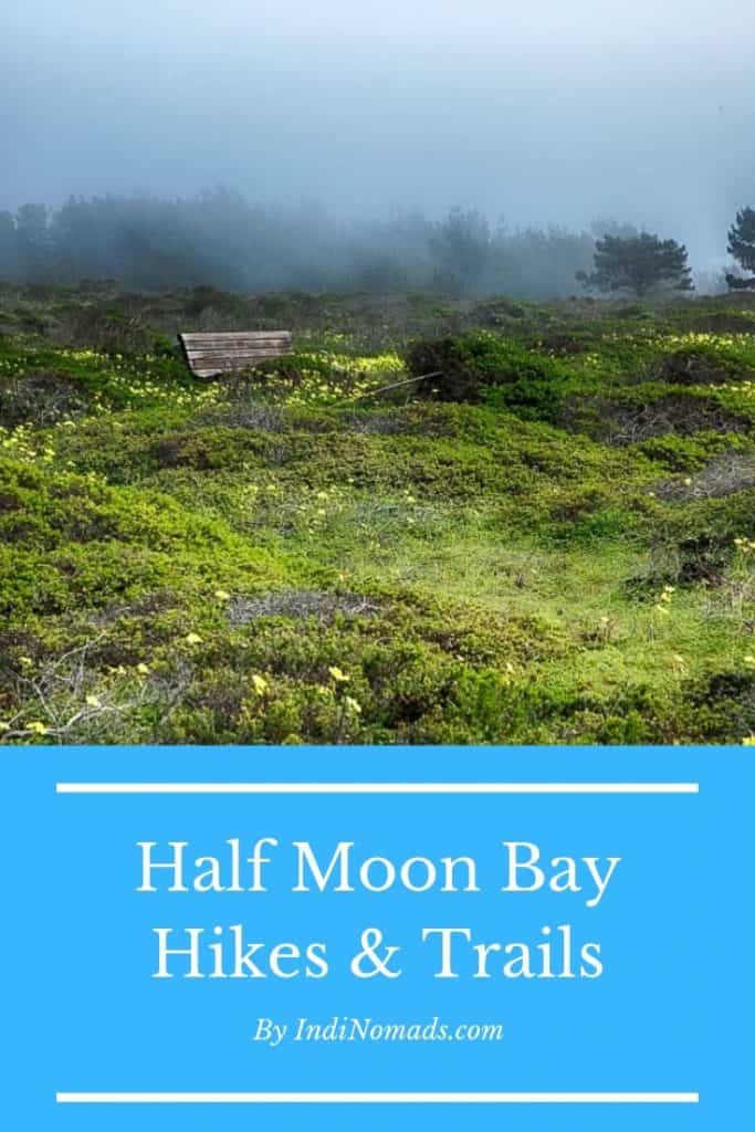
Pin for later planning.