
When visiting Connemara region in Ireland, one of the top things to do is to take explore the stunning nature Connemara has to offer. Connemara hikes and walks will leave you worked out by exposing the wild heart of the region. Be sure to include Connemara walks in your list even if its a small walk around Connemara national park. This region offers walks and hikes that is very inclusive of your level of fitness.
Article Contents
Connemara Hikes and Walks
I will break down this article into two sections. Majority of the hikes you see in google search are going to be in Connemara National Park, but there are also absolutely gorgeous Connemara walks that are worth taking outside of the national park area. I want to make sure to cover those and give you options on how you can to spend your walking time in Connemara. And most of the hikes highlighted here are in and around highway N59 for convenience.
Connemara Walks outside of National Park
I have listed hikes and walks in the order of difficulty, easy ones that you can do also do with little kids first and increases in difficulty as you move down the list. This difficulty level rating is of course subjective.
Kylemore Abbey and Victorian Garden Walk:
This is a gentle walk through the beautiful gardens of the Kylemore Abbey estate, with views of the Connemara mountains in the background. This walk is perfect for everyone including kids. You walk as much as you want and take your time to enjoy the victorian garden.
Length:6 km
Terrain: Flat
Starting point: https://goo.gl/maps/VkqTavyuCUaMwkJ29
Clifden Castle and Sky Road Walk:
Park the car the city center parking lot and walk along the beach road for 2km. At the end of the Beach Road there is a right turn up a winding hill. Follow this road for 1km, after which you arrive at the gate to Clifden Castle. It’s a really nice way to experience the beach, town of Clifden and the castle by foot.
Length: 6 Km
Terrain: Easy walk along the coast and to the castle
Starting point: https://goo.gl/maps/rG6NHauKs6KXtYUR8
Ballynahinch Estate Walk:
Approximately over 6km of walking trails along the Ballynahinch River and Lake or Old Railway Line, there are walks to suit all abilities and interests. The riverside and lakeside walks twist along the water’s edge. Kids will enjoy the walk and there are benches along the way to stop for picnic.
Length: ~6Km
Terrain: Flat
Starting Point: https://goo.gl/maps/WXuDsL1N2iKr2oTh7
Doonen Greenway:
This is a route officially designated as a walking route by the city. Once you find a parking, cross over the stone bridge to Doonen road and follow the marked walking trail to Doonen and Ardbear loop for a nice relaxing 12km walk.
Length: 12km
Terrain: Flat and easy
Starting point : https://goo.gl/maps/muh3nRTUt7FTbJmq5
Derrygimlagh Bog Walk:
This walk around Bog (marsh land) has historical significance. In 1907, the great Irish-Italian innovator, Guglielmo Marconi, combined cutting-edge technology and business acumen to achieve the first successful commercial wireless transmission across the Atlantic from Derrigimlagh.
The walk has boardwalk that you need to follow. Don’t walk outside of the boardwalk to be safe.
Length: 5 km
Terrain: Flat and paved path
Starting point : https://goo.gl/maps/Lo3fs38B6qz7Ngyn6
Cleggan Head Walk :
A coastal walk that takes you through Cleggan fishing village, a neolithic burial site and leads to a beach to soak your feet as you breath in fresh Irish air. Walk towards Selerna Beach in the paved road and explore the region. Just like most of the walks pointed out in this post, this one also doesn’t have a designated trail marking.
Length: 5Km
Terrain: Flat
Starting point: https://goo.gl/maps/6aVvTzRzJqxefhv6A
Clonbur Wood Loop walk:
This loop weaves through mixed woodland, shore of lovely Lough Mask, followed by forest road and track. You will see some of the Lough’s many islands and the striking geology of limestone pavement and cross the Clonbur River, with lovely views of the lake. Feel free to walk over to the island to add to the mileage.
Length:7.5 km
Terrain: Flat
Starting point: https://goo.gl/maps/4yG2rpyFjm9pLXD59
Map:

( Source: https://www.coillte.ie/ )
Tully Mountain:
This hike gives amazing view of the twleve bens (mountain peaks) from one side and the ocean view on the other side. Absolutely gorgeous walk worth taking even if there is no clear trail marking.
Length: 4km up and down
Terrain: Steep mountain terrain of 357 meters
Starting point: https://goo.gl/maps/yHXGUEkDGGpXug6o8
From the pier continue walking west along the road about 500 meters where you will be at the top of the small hill. Turn right off the road at this point. You should see footsteps and a gate up to your right. You might walk through private property. So, be mindful.
First you will reach a small hill. From the top of the first continue west in the direction of the next peak, and the 2 peaks after that. Continue walking by keeping both small lakes on your right hand side, and then in the direction of the sea cliffs until you reach the hill top.
Some Wind/Rain Proof Hiking Gear We Use:
Errisbeg Walk:
Wear a good pair of shoes that can withstand muddy, wet and boggy trail. There is no clear walking trail marked to follow. But, it is worth hiking up for the spectacular view of the Atlantic ocean on one side and Connemara villages along the way.
A good waterproof walking shoes like the one I have listed below is highly advisable.
Length: 6 KM
Terrain: Steep terrain with 980ft elevation, but relatively easy to hike
Starting point: https://goo.gl/maps/pkhTnaD6E3Ksxk8c6
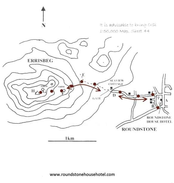
(Source: roundstonehousehotel.com )
Cashel Hill Hike:
Stunning view of the ocean as you turn back and watch. The hike can be wet and boggy. Wear boots to make sure you are prepared. The hike has really nice view of the ocean as its a stand alone mountain top from Cashel village.
Length: 4 KM
Terrain: Steep terrain with 1010ft elevation, but relatively easy to hike
Starting point: https://goo.gl/maps/GZ8JfBVY4oBCZSsC7
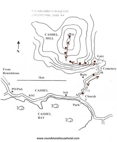
(Source: roundstonehousehotel.com )
Claddaghduff quay to Omey Island walk:
Mysterious tidal island that can be crossed by foot when the tide is low. This is no ordinary hike, you have to time it right. The best way to time it right is by stopping at the Sweeney’s shop/bar and ask them the current weather conditions and when they think the hike can be attempted. Once you reach Omey Island, there is literally nothing there but an old grave yard and nature in it’s absolute self. Sometimes you might be the only one in the entire island. A great walk if you are looking for some solitude and time to reflect.
The island is absolutely worth walking to. The water is beautiful on a nice summer day for sure.
Length: 8KM
Terrain: Flat
Starting point: https://goo.gl/maps/K9LwpeYVvkgQUqnA7
Check out this video by a vlogger:
Map: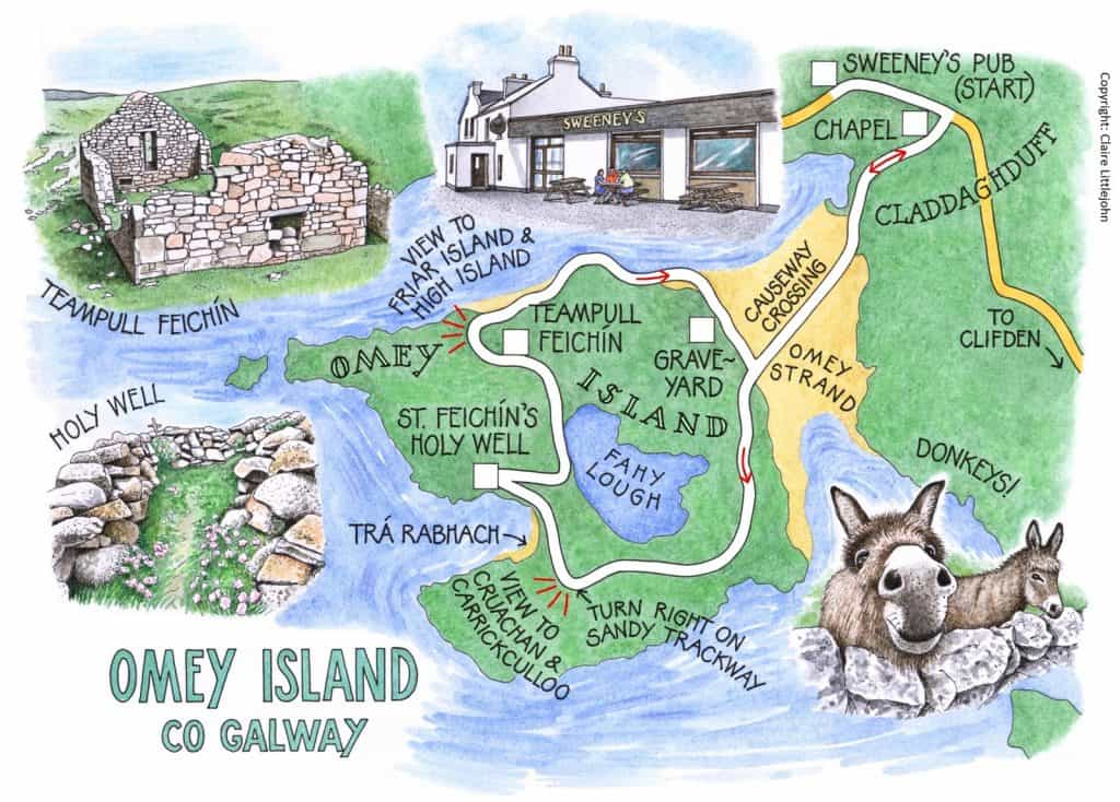
( Source: http://www.irishislands.info/ )
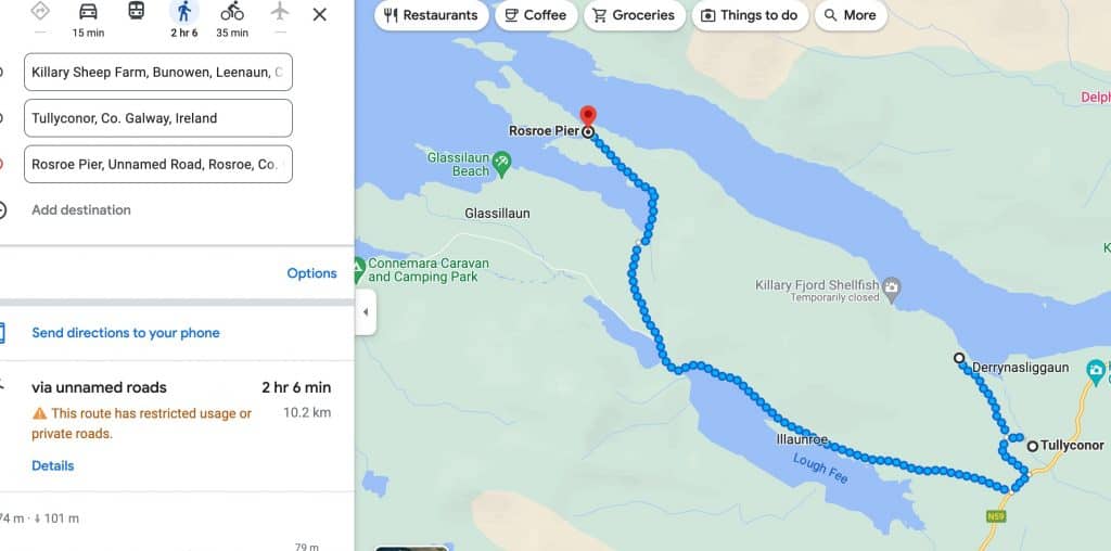
Killary Fjord Famine Trail
During the potato famine in 1845, locals were trying to get a job by building roads that lead to nowhere, so they can buy food.
This loop that you are about to embark on is where people worked hard to make their ends meet and ,many failed. Don’t let that dark past stop you from exploring the Killary Fjord, one of the most impressive ones in Ireland.
You don’t have to walk the whole trail. You can walk as much as you want and still get a good view of Killary Fjord.
Length:
- 14 KM out and back
- ~ 20 KM partial loop
Terrain: Flat
Starting point: Put direction for Killary Sheep farm in your gps and park anywhere along Highway N59 or near sheep farm. There is no official parking lot for this hike. You can park along the road as long as you are not blocking the traffic for other cars and the sheep of course.
Map: https://goo.gl/maps/TjdbNE9nCjZ3GHH39
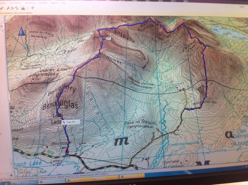
Glencoaghan Loop : The most difficult hike !
If you want to experience one of the most rugged beauty of Connemara region, take of this challenge that will take you through 6 different mountain peaks, that involves all types of challenges such as rock climbing, scrambling, walking through scree, sliding etc.,
You will cover Benlettery Bengower, Benbreen, Bencollaghduff, Bencorr and Derryclare peaks.
It is recommended that you do the hike in anti-clock wise direction.
Tips:
- It can take anywhere from 9 hours to 13 hours to hike this trail depending on your fitness level and weather
- Always be prepared for extreme wind and rain
- Take food and water for longest predicted time
- Do the hike in anti clock wise direction
- Shorten the by stopping at Benlettery hostel and hitch hike the next 5KM to your car
- Always go with a partner to be safe
Length: 16KM
Terrain: Strenuous mountain terrain
Starting point: Starting point for this hike can be one of the most confusing ones and also the navigation of the trail. I highly recommend getting a professional gps map to get to this hike. Here are some recommendations :
https://www.wikiloc.com/mountaineering-trails/glencoaghan-horseshoe-98005928
https://www.alltrails.com/trail/ireland/county-galway/glencoaghan-loop–2?u=i
To get a glimpse of the terrain, watch the video of this woman taking on the challenge over two days where she hikes all 12 bens.
6 bens can be done as a day hike like I have mentioned above.
Map:
Connemara Walks in Connemara National Park
As you enter Connemara National Park, stop at the visitor center first. We went to the park in April and there was plenty of parking available. However, I can only imagine how crowded it can get in the warmer months. Go early and carpool if you can.
Lower Diamond Hill Walk:
A well marked walk that hits the highlights for those who prefer to keep it short. You can still see Connemara ponies in the ranch area, of course horse willing, and get to a view point where the vista opens up to the valley.
Length: 3Km
Terrain: Mostly flat
Staring Point: Connemara National Park visitor center
Upper Diamond Hill / Peak Walk :
A well marked walk that hits the highlights and extends further from lower Diamond Hill Walk. You can still see Connemara ponies in the ranch area, of course horse willing, and get to a view point where the vista opens up to the valley. You will walk up on the trail that will connect to Diamond Hill Peak hike. That’s a tougher one and not for everyone. Also, check with visitor center to make sure the wind conditions are suitable for the hike.
Length: 9Km
Terrain: Uphill to 445m
Staring Point: Connemara National Park visitor center
Diamond Hill Loop:
This is certainly the most popular walk in the national park for obvious reasons. The hike covers great views of the park, Diamond Hill in the backdrop and coastal view all packed in one. You will not reach the peak itself as a part of this hike. If you want to go to the peak, you will choose Upper Diamond Hill hike. This hike was something even my 5-year old was able to do. It wasn’t an very easy hike, but my 5 year old is used to hikes.
Length: 7 Km
Terrain: Some uphill involved
Staring Point: Connemara National Park visitor center