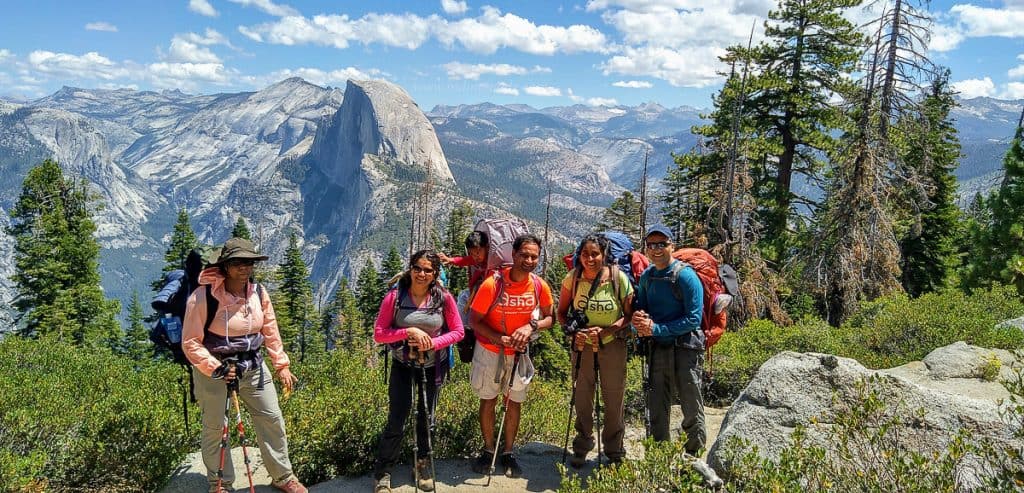
Pohono Trail is one of the popular backpacking trails in Yosemite backcountry and for obvious reasons. It’s stunning to say the least. This 13-mile long trail can be done in various combinations as I described below.
- From Glacier Point to Tunnel View – Net loss in elevation.
- From Tunnel View to Glacier Point – Net gain in elevation.
- Tunnel View to Dewey Point and back to Tunnel View
- Glacier Point to Dewey Point and back to Glacier Point
Given the 13-mile distance, the hike can technically be done in one day. But, keep in mind, it’s a really challenging and strenuous one-day hike to do.
So, we chose to do it as a backpacking hike by breaking at Dewey point for the night. Trust me, it was the best ever decision. Sunrise and sunset at Dewey point are certainly not to be missed.
Article Contents
Pohono Trail
Glacier point to Tunnel view is considered easy due to the net loss in elevation. First 8 miles up to Dewey point is really gradual and the remaining 5 miles are guaranteed to shake your knees up with steep downhills.
Pohono Trail Backpacking Permit
It is entirely possible to go directly to the wilderness station and get on the day permit. However, during the peak summer, I wouldn’t bet on. I applied for the wilderness permit for Pohono Trail 6-weeks before the trip. We did the hike during the first weekend in August, 2019.
It was definitely the right decision to have applied for the permit ahead of time. When we got to the campsite, it looks like it was at full capacity.
To apply for the permit, use this link: https://www.yosemiteconservancy.org/yosemite-wilderness-permit-request-form
Here are the details you would need to fill the form:
Entry Trailhead: Pohono Trail (Glacier Point)
Exit Trailhead: Pohono Trail (Wawona Tunnel/Bridalveil Parking)
Campsite: Dewey Point
Changing the Dates on Permit:
When we found out that we can’t make it on the weekend we had originally gotten the permit for, I immediately called the ranger station to see if I can postpone. The ranger helped find a weekend that would work for us and did the change without any issues.
And, they also allow anyone with the permit print out to pick up the permit. Technically, everyone should go to the permit pickup, because they give a talk on how to behave in the wilderness and how to handle wildlife. It’s extremely important to listen to that lecture, if this would be your first time backpacking in Yosemite wilderness, as it is very different from other backpacking trips you might have done.
Pohono Trail Length:
Total length of the trail is 13 miles from Glacier point to Tunnel view. However, you will find varying informations on how far the Dewey point is, how far the Bridal veil creek is from glacier point etc.,
Here is what we found out as we hiked through the trail.
From Glacier point to Dewey Point: 7.9 miles. It’s a gradual uphill to Dewey point.
From Dewey Point to Tunnel View parking lot: 5.1 miles
This is what the trail markings said and matched with our garmin gps watch as well.
Pohono Trail Transportation:
The most challenging part of this point to point backpacking trip or even a one day 13-mile hike is the logistics involved in having cars in two different parking lots.
Here are the ways to make it happen:
- Drive two cars. Leave one at each end.
- Drive one car that you leave at starting point and hitch hike your way after finishing the hike.
- Drive one car, leave it at the end of the trail. Book a bus to take you to starting point. You can find information on how to book a bus: https://www.travelyosemite.com/things-to-do/guided-bus-tours/
We were a group of 6 and chose to drive in two cars and parked one car at each end. Keep in mind, on a summer weekend, it will take a good one hour to get from Tunnel view to Glacier point and vice-versa.
Pohono Trail Camping:
You have to camp at least 4 miles away from the trail head start. For us that meant we had to cross the Bridal veil stream to camp. In any case, Dewey point is everyone’s target for camping. But, some reason, you can’t reach Dewey point before dark, find a flat spot anywhere on the trail after the Bridal veil stream.
Once we reached Dewey point, there were already at least 10 other tents set up for the night. But, there is space for everyone in the wilderness. We still found nice and flat spots for 3 tents for our group of 6.
Camping Before Pohono Trail Hike:
The night before starting the hike, we reached Yosemite late at night. As a part of the backpacking permit, we are allowed to camp stay at backpacker campsites the night before and night after the hike for $6 per person, without reservation.
Here is the list of backpacker campgrounds: https://www.nps.gov/yose/planyourvisit/bpcamp.htm
However, you do need to have the permit with you to camp at these grounds. Since we knew we would reach at 10PM and won’t have time to pick up the permit before 5PM, I booked a campsite outside the park.
Yosemite Lakes RV Resort campsites are a little expensive, but for the convenience, very worthy.
One good thing is there is no bear activity at the resort. So, there is no need to bear proof the food in the middle of the night.
Pohono Trail Map:
Invest in a Yosemite backcountry map that you can buy at any visitor center or wilderness center. It’s well worth the money.
However, to get an idea of how the trail looks like, here is a cropped view of the map published here.
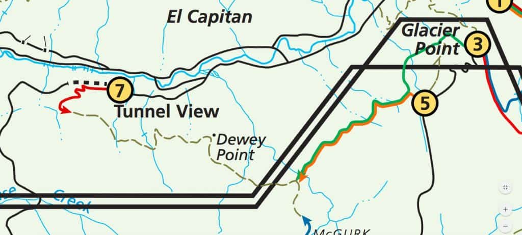
We didn’t carry any map with us on the trail. Trail is fairly well marked with a little bit of confusion at the second half.
From Glacier point to Dewey point, it’s really impossible to get lost. However, we still almost got lost. As we started the hike there is road crossing right after Glacier point. After the road crossing, the trail head continues on the right hand side. We didn’t notice that and just walked along the road before we realized we were going in the wrong direction.
After this little confusion, it’s really easy to follow the trail. There will be lot of people hiking to taft point and back. And there are trail markings including sentinel dome detour (which we chose not to do) etc.,
After Dewey Point and towards Tunnel view, there are a couple of points where it can get confusing. About a mile from Dewey point, there was supposed to be a sharp left and the trail also continues straight. If we didn’t see other hikers, we would have gone straight. I wonder if that straight trail indeed continues or not.
This left turn will take you all uphill to a view point. If you are not hiking all uphill, question yourself. And there will be another junction that divides the trail to tunnel view parking lot and some other parking lot. That’s also easy to miss if you are not paying attention or immersed in a conversation like we did. But, at least it’s clearly written there.
So, it’s certainly doable without a map.
Pohono Trail Water:
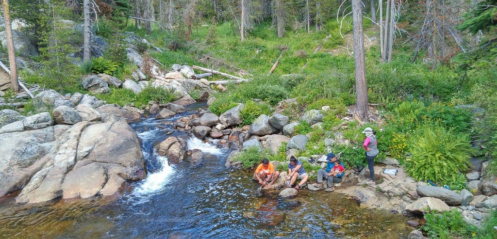
As you start the hike from Glacier point, the first main water source source is Bridal Veil stream. Before reaching Bridal Veil, there are some really small creeks you will pass through, after Taft point. At first, we thought the small creek was indeed the Bridal veil stream and almost decided to start filter the water.
But, I remembered the ranger said there is a bridge we will cross at Bridal Veil. So, we chose to walk another less than half a mile to get to the real deal bridge and a huge and gushing stream of water.
And this is the pretty much the only big source of water before Dewey point. In case, you run out of water at Dewey point, you would have to walk down to either Bridal Veil or walk further towards Tunnel view to get water. Dewey point itself it completely dry and absolutely no water there.
After Bridal Veil, and before dewey point, there was a really really small creek of running water, must have been approximately half way between those two points. But, I wonder if that’s seasonal. May not be a reliable source of water after all.
Here are our water purification / storage system that worked really well for us:
Water Filter:
Here is why I love this water filter:
- Katadyn water filter is that it’s really light weight and rolls small as you pack your backpack light.
- Filters 2 liters per minute
- The filter itself only needs to replaced after filtering about 1000L. For us that is likely to be about ~75 backpacking trips later.
- Plus you can use this drink water directly out of it.
- And acts as a water storage.

Water Bottles:
We had carried at least 12 L of water for 2 adults and 1 kid for the night and next day morning. Since all our cooking was home made dehydrated food, we needed water to cook. So, we had taken collapsable, soft water bottles that can be filled.
Platypus Ultralight Collapsible SoftBottle with Push-Pull Cap, Trees, 1.0-Liter

Water Bladder for hike:

Personal Hygiene at Pohono Trail:
While backpacking at Yosemite, you are required to keep the used toilet papers in the bear canister. Does that sound yucky to you ?! Because, it is yucky. So, do yourself a favor and get a personal bidet.
This bidet is pretty light weight and works wonders.

Bear Proofing for Pohono Trail:
At the permit pick up, be ready to attend a 30-minute talk on how to bear proof yourself and the food by the ranger. And it’s extremely important to listen to and strictly follow what they advice.
For our group of six with a diaper baby, we used BV500 bear canister. This had to fit everything listed below into it.
- Diapers, wet wipes, creams
- Food, snacks
- Toiletries
We made the mistake of not rehearsing how much can go into the bear canister.

At the beginning and end of trail, there are bear lockers to leave your extra food and toiletries. Don’t leave any valuables, but it’s fairly safe to leave stuff here. We had to leave extra food at the tunnel view parking lot bear lockers.
- It’s useful to leave food here because when you return there is food to eat.
- You don’t want to carry anything that won’t fit into the bear canister.
Since we had only one canister, we had to get creative. Everyone had extra personal items that were scented and didn’t fit into the bear canister. Also, the used diapers also need to fit into the same bear canister.
Had we planned better, we would have taken two bear canisters.
So, we ended up putting a bag with things we are ok to lose to bear in a bag and tied it up on a tree, really away from the campground. If a ranger had caught us, this would have been a citation for sure. But, we had no choice. Really poor planning on our end. Especially the diapers.
Luckily nothing happened. Next day morning the bag was still there on the tree, intact.
End of Pohoto Trail Backpacking Trip:
From Dewey point to tunnel view the first mile is relatively flattish. Second mile is uphill and from then on the real deal downhill starts.
Non-stop, cruel downhill with rocks that took me a good 2 hours to climb down. Don’t under estimate the downhill here.
What’s made this section even more interesting was the fact that we actually encountered a mommy bear with two cubs. There were four of together at that time. So, we decided to talk really loud and just march along.
Mommy bear cooperated and crossed the trail in front of us along with her cubs and walked away. However, she kept looking back at us as we disappeared from her view.
Yosemite only has black bears. They are not interested in eating humans. However, they are certainly very protective of their babies and can attack humans if they sense threat.
Two things happened on the way back:
- We ran out of water to drink
- And didn’t have enough food on us.
The plan was to finish the hike before lunch. But, the downhill made it really difficult for me to hike down and we took a total of 4 hours for the 5.1 mile hike. Plus we started the hike at 9AM, so we were going past lunch time by the time we reached the parking lot.
I was starving at that stage. So, a word of caution, plan ahead to have food with you on the way out.
Overall, a great beginner friendly hike. We had beginners in our trip and they did great.
Pin for planning your trip !